 I was fortunate to have had time to attend the International Conference of Crisis Mappers (ICCM) 2011 in Geneva. This conference is an interesting confluence of GIS, social media, crowd-sourcing, mobile and web-based application and participatory mapping all used for early warning for rapid response to complex humanitarian emergencies.
So it was an interesting set of enthusiastic, passionate, intelligent and committed individuals and organisations who met up for 2-3 days of conferences, self-organised sessions, ignite talks and demonstrations. With my two hats on (MapAction and Esri UK); I was interested in seeing how my areas of interests (GIS, Cloud Computing, Humanitarian response and technology) would mix and mesh in this febrile environment.
I started my conference a day early with an ArcGIS for United Nations introduction looking at the new features of ArcGIS 10.1, increased utilisation of cloud based resources and an expansion in the licensing model. This was run by two Esri Inc staffers who I have been in contact with: Ryan Lanclos and Jeff Barayani. Esri Inc’s own involvement in humanitarian response was highlighted and a nod to the increasing importance of crowdsourced data and social media was made several times. This session lasted until 12:00 when we left the building and made our way to the conference hall.
On arrival, the main event kicked off and was attended by over 300 people from across the entire spectrum of GIS, social media, crowdsourcers and NGOs. A big lunch (funded by Esri Inc) meant that we all trooped into the main auditorium on full stomachs and sat down to an afternoon of ignite talks: 5-minute briefings with a maximum of twenty slides pre-set to change every 12 seconds or so. It made for a rapid-fire delivery of content.
I made notes on the talks but the highlights for me include the following:
Adam Finck of the NGO ‘Invisible Children’ and their implementation of the Lord’s Resistance Army’s (LRA) Crisis tracker. The talk concentrated on an early warning system for those on the frontline, warning of ongoing attacks, tracking the movements of the LRA and exposing the atrocities committed. The tool’s role is to spread the news of one of Africa’s longest wars. Advocacy through social media acts as an agent of change. The data and application is all hosted via Salesforce.com, the well-known cloud-based CRM provider.
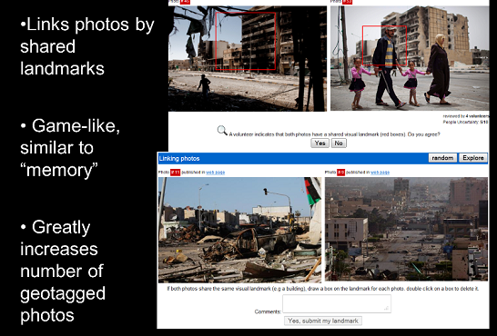
Lars Bromley from UNOSAT and ‘PhotoGeotagger’. A very interesting talk that dealt with a low-cost method of linking photos of large areas of (relatively) low resolution data via crowdsourced methods. An example would be for cheap images, put onto the internet to be scoured by 100s of persons trying to identify camps for either refugees or internally displaced persons (IDP). Photos taken over a time period can be used to identify landmarks after an event that may have rendered features invisible. Once geotagged this data can be integrated into a GIS for further analysis.
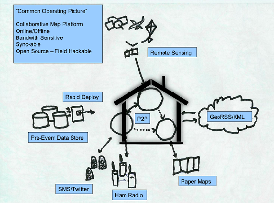
Nigel Woof from MapAction discussed the importance of a ‘place’ for all actors to gather together and for peer-to-peer (P2P) to occur. While there were many networking tools available, it is the knowledge of a well-known place (physical or virtual) that enable the gathering of peoples and the exchange of ideas and knowledge. The plethora of social media applications, online collaboration tools, crowdsourced data and the pervasiveness of the internet actually makes the establishment of a well-known ‘place’ all the more important, lest a user is cast adrift on a sea of data, unable to make sense of it or make the necessary connections to produce meaningful work and results. Now, with this establishment of a place, peer-to-peer sharing of data, information and experiences can be done easily and naturally. Something that is called ‘Humanitarian Speed Dating’.
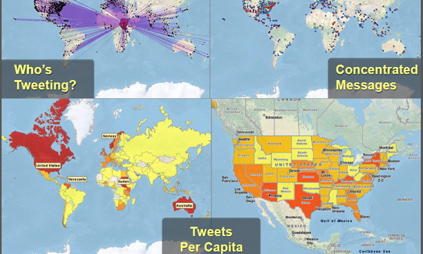
Jeff Barayani from Esri Inc, ‘GIS and Crowdsourcing’ demonstrated that one of the major players in the GIS world was serious about supporting this area of work with an Ushahidi plug-in to better enable the mapping of events as they occurred in real time and the announcement of an OpenStreetMap (OSM) Editor Add-in for ArcGIS for desktop. Esri Inc was also going to be a node for OSM. So the thrust of the talk detailed how Esri Inc used social media and VGI (volunteered geographic information) to gain a better insight into improving situational awareness for all actors. Thousands of people will all have thousands of bits of information that could be shared and acted upon. Additionally, Esri would put into place services and products that would mobilise their own user base to contribute. GIS and its power to manage spatial information is now a powerful tool in crisis mapping.
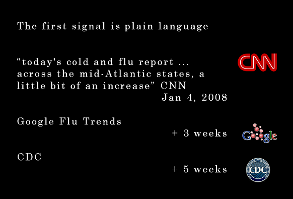
Robert Munro from Epidemic IQ and ‘Tracking Epidemics through crowdsourcing’. One of the most thought-provoking and memorable talks for me. This organisation showed how they would use sophisticated algorithms to scour the internet for small tidbits of information that individually would mean little but taken together, could paint a much more coherent picture. For example, it is increasingly common for people to use the internet to research about illnesses that they or their family are suffering. A spike in such search terms, in a localised area could give the first warnings of an outbreak. Fascinating stuff.
The first day ended late with many of the participants disappearing off to various bars and pubs to continue the discussions over beer and food. What I found invigorating was the enthusiasm of everyone involved and the disappearance of professional boundaries. We started off as being GIS specialists, IT consultants, enthusiasts & students. Within hours, we were all speaking each other’s language. It is also of great interest that there are many non-GIS practitioners who are using GIS with ease, competence and comfort. Professionally, it is a cautious note that the GIS field might overtake the more established, traditional actors.
Just before the conference hall was closed, the delegates were all asked to either put forward a topic for discussion or to nominate for one already suggested. Since social media played such a prominent part in the conference, it wasn’t too surprising that all this was organised via twitter, facebook and GoogleDocs. I looked at the scrolling list of subjects and nominated my choices, eager for day 2.